
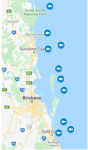
TAKE a selfie with one of Queensland’s fish-attracting devices and enter a competition to reel in some wicked prizes! GPS Marks
There’s 10 FADs deployed from Double Island Point to the Gold Coast, so show Fisheries Queensland how much you’re loving fishing in this weather and you could win one of the prizes listed below. GPS Marks.
How to enter:
To enter, take a photo with one of the FADs (GPS marks below) and upload it using the entry form found by clicking here.
Entries must be uploaded by 11.59pm, February 13, 2020.
Don’t forget to download the Queensland rec fishing app for instant access to Queensland’s fishing rules anytime and anywhere.
Prizes
1st prize: Garmin Echomap Plus 95sv (donated by Garmin) and 4 lures (donated by Wilson Fishing). wicked prizes
2nd prize: ATC Virtuous 5000H Reel on a Venom VS12 Spin Rod (donated by Wilson Fishing), $500 BCF voucher (donated by BCF) and 4 lures (donated by Wilson Fishing).
3rd prize: $500 BCF voucher (donated by BCF) and 2 lures (donated by Wilson Fishing).
4th prize: 4 lures (donated by Wilson Fishing).
5th prize: 2 lures (donated by Wilson Fishing).
Southeast Queensland FAD GPS marks
(Ordered from bottom to top when looking at the map).
- FAD 1: Gold Coast 24s. Latitude (DDM): 27° 59.268’S; Longitude (DDM): 153° 31.747’E
- FAD 2: Gold Coast 50s. Latitude (DDM): 27° 55.790’S; Longitude (DDM): 153° 45.198’E
- FAD 3: Gold Coast 36s. Latitude (DDM): 27° 48.408’S; Longitude (DDM): 153° 37.472’E
- FAD 4: Stradbroke offshore. Latitude (DDM): 27° 17.029’S; Longitude (DDM): 153° 37.672’E
- FAD 5: Moreton offshore. Latitude (DDM): 27° 05.797’S; Longitude (DDM): 153° 34.177’E
- FAD 6: Bribie offshore. Latitude (DDM): 26° 55.735’S; Longitude (DDM): 153° 31.775’E
- FAD 7: Mooloolaba 10nm. Latitude (DDM): 26° 35.908’S; Longitude (DDM): 153° 19.686’E
- FAD 8: Mooloolaba east. Latitude (DDM): 26° 32.149’S; Longitude (DDM): 153° 34.429’E
- FAD 9: Noosa. Latitude (DDM): 26° 19.868’S; Longitude (DDM): 153° 19.284’E
-
FAD 10: Double Island offshore. Latitude (DDM): 25° 53.075’S; Longitude (DDM): 153° 21.907’E